Geography
Geography
Trinidad and Tobago are the southernmost islands of the Caribbean archipelago, and are geologically an extension of the South American continent.
Trinidad is separated from Venezuela by the 11 kilometre straits of the Gulf of Paria.
Trinidad
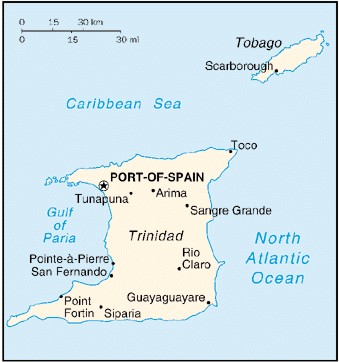 Location: Latitude 10 1/2°N, Longitude 61 1/2° W
Physical Area: Rectangular in shape, measures 60 km by 80 km.
Total Area: 4828 square kilometres
Major Cities: Port of Spain (capital), San Fernando
Major Towns: Arima, Point Fortin, Chaguanas
Trinidad possesses vast tracts of rich rain forests in the Northern Range, with the highest peak, El Cerro del Aripo, ascending to a height of 940 metres above sea level. In contrast, you will find flat lands, mostly agricultural, in the Central Plains, while Southern Trinidad is full of gently undulating hillsides.
Tobago
Location: Latitude 11°N, Longitude 60°W
Physical Area: Fish-shaped, measures 42 km) by 10 km.
Total Area: 300 square kilometres
Major Towns: Scarborough, Roxborough, Charlotteville
Tobago's eastern interior rises steeply into tall peaks with lower lying lands that include a protected reserve area. Tobago's topography consists mainly of volcanic rock, which is in stark contrast to its Caribbean blue waters.
Trinidad and Tobago comprises 5128 square kilometres, about one and a half times the size of the state of Rhode Island. The territory enjoys a tropical climate with average maximum temperatures of 32°C, (89°F). Tobago's temperatures are cooler, owing to the more constant north east trade winds.
The Republic of Trinidad and Tobago is located on two islands in the Caribbean Sea off the east coast of Venezuela. The area of Trinidad is 1,864 square miles, and Tobago's area is 116 square miles. The combined area is slightly smaller than the state of Delaware. Tobago is 20 miles from the island of Trinidad. The nearest neighboring country to the islands is Venezuela, which is seven miles away.
There are three low mountain ranges that run east to west across Trinidad with a large plain in between where sugar cane is grown. Parts of the east and west coasts of the island are swamps. The highest point on the islands is El Cerro del Aripo, which is 3,085 feet high and located in the northern mountain range on Trinidad. Much of the north of the island is covered in forests. Tobago has beautiful white sand beaches because of the coral located around the island. The center of the island is hilly and the south and west coasts are flat.
The climate of Trinidad and Tobago is tropical, so it is warm all year there. The average temperature ranges from 73 to 90 degrees. There are two seasons: a dry season from January to May and a rainy season from June to December. Fortunately the islands are not in the usual path of Atlantic hurricanes.